<div class="csl-bib-body">
<div class="csl-entry">Trzcina, E., Hanna, N., Rohm, W., Kryza, M., & Hordyniec, P. (2022, June 6). <i>TOMOREF operator as a boost to the data assimilation system</i> [Poster Presentation]. 8th International Symposium on Data Assimilation (ISDA), Canvas Stadium, Colorado State University, Fort Collins, Colorado, United States of America (the). http://hdl.handle.net/20.500.12708/154322</div>
</div>
-
dc.identifier.uri
http://hdl.handle.net/20.500.12708/154322
-
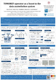
dc.description.abstract
The number of extreme weather events in Europe is constantly increasing. Severe storms bringing strong wind, heavy rain, and floods cause deaths and widespread property damages. The GNSS tomography technique, developed in recent years, provides a 3-D field of humidity in the troposphere. Contrary to the operationally assimilated Zenith Total Delay (ZTD) observations, representing an integral measurement along the vertical, GNSS tomography provides a suitable vertical resolution to map the outputs to meteorological parameters in various height layers. Hence, this technique can supply weather models with high-quality observations.
To combine the GNSS tomography‐derived 3‐D fields of wet refractivity with the Weather Research and Forecasting (WRF) Data Assimilation (DA) system, a new observation operator, called TOMOREF (TOMOgraphic REFractivity), was built. The new tool has been tested based on wet refractivity fields derived during a very intense precipitation event in central Europe in May 2013. The results were validated using radiosonde observations, synoptic data, ERA5 reanalysis, and radar data. In the presented experiment, a positive impact of the GNSS tomography data assimilation on the forecast of relative humidity (RH) was noticed (an improvement of root‐mean‐square error up to 0.5%). Moreover, within 1 hour after assimilation, the GNSS data reduced the bias of precipitation up to 0.1 mm. Furthermore, the assimilation of GNSS tomography data had more influence on the WRF model than the ZTDs, which confirms the potential of the GNSS tomography data for weather forecasting. Another experiment testing tomographic outputs assimilation was conducted in calm weather conditions in the Netherlands in February 2018, focusing mainly on wind parameters forecasting. The aim of this case study was to obtain reliable weather forecasts to support the wind power sector. Therefore, ZTDs and gradients (north and east) for 31 GNSS stations were estimated using goGPS software and processed using tomographic techniques. The result water vapor field was then assimilated via the TOMOREF operator. The obtained weather forecasts (wind speed, temperature, and relative humidity) were validated against radiosonde data and a network of 50 KNMI weather stations.