<div class="csl-bib-body">
<div class="csl-entry">Haines, J. C., Peppa, M. V., Iliadis, C., Mills, J. P., Glenis, V., & Mandlburger, G. (2025). Evaluation of ULS Bathymetry for Hydrodynamic Modelling. In G. Mandlburger, L.-A. Gueguen, J. Rhomberg-Kauert, F. Menna, & E. Nocerino (Eds.), <i>The International Archives of the Photogrammetry, Remote Sensing and Spatial Information Sciences : 3D Underwater Mapping from Above and Below : 3rd International Workshop, 8–11 July 2025, TU Wien, Vienna, Austria</i> (pp. 115–122). Copernicus. https://doi.org/10.5194/isprs-Archives-XLVIII-2-W10-2025-115-2025</div>
</div>
-
dc.identifier.uri
http://hdl.handle.net/20.500.12708/220826
-
dc.description.abstract
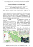
The importance of accurate and reliable DTMs are paramount for hydrodynamic modelling. Currently, bathymetry is either not considered or a simpler mathematical representation of the river is created from observed cross sections for hydrodynamic models. Topographic and Bathymetric LiDAR creates centimetre resolution bathymetry and topography. However, it has not been applied into large scale hydrodynamic modelling. Following a major flood event in September 2024, a large fieldwork campaign on the Pielach River, Lower Austria, was conducted to capture the environmental changes using Topographic-Bathymetric LiDAR. Metre resolution DTMs of the bathymetric and topographic environment were created to produce flood inundation maps from crewed and uncrewed aerial mapping systems. Using the observed flow data of the September 2024 storm, resulting flood models prove the inclusion of bathymetry can produce reliable flood models with depths of greater than 6 m modelled. Due to the lower flying altitude and tactical flight paths of ULSs, it is possible to identify regions occluded by vegetation that would otherwise be overlooked by crewed Airborne Laser Scanning methods to produce more reliable flood models.
en
dc.description.sponsorship
FWF - Österr. Wissenschaftsfonds
-
dc.description.sponsorship
FWF - Österr. Wissenschaftsfonds
-
dc.language.iso
en
-
dc.relation.ispartofseries
ISPRS
-
dc.rights.uri
http://creativecommons.org/licenses/by/4.0/
-
dc.subject
Bathymetric Flood Modelling
en
dc.subject
Bathymetric Surveying
en
dc.subject
Digital Terrain Models
en
dc.subject
Hydrodynamic Modelling
en
dc.subject
Topo-bathymetric Laser Scanning
en
dc.subject
Unmanned Laser Scanning
en
dc.title
Evaluation of ULS Bathymetry for Hydrodynamic Modelling
en
dc.type
Inproceedings
en
dc.type
Konferenzbeitrag
de
dc.rights.license
Creative Commons Namensnennung 4.0 International
de
dc.rights.license
Creative Commons Attribution 4.0 International
en
dc.contributor.affiliation
Newcastle University, United Kingdom of Great Britain and Northern Ireland (the)
-
dc.contributor.affiliation
Newcastle University, United Kingdom of Great Britain and Northern Ireland (the)
-
dc.contributor.affiliation
Newcastle University, United Kingdom of Great Britain and Northern Ireland (the)
-
dc.contributor.affiliation
Newcastle University, United Kingdom of Great Britain and Northern Ireland (the)
-
dc.contributor.affiliation
Newcastle University, United Kingdom of Great Britain and Northern Ireland (the)
The International Archives of the Photogrammetry, Remote Sensing and Spatial Information Sciences : 3D Underwater Mapping from Above and Below : 3rd International Workshop, 8–11 July 2025, TU Wien, Vienna, Austria
-
tuw.container.volume
XLVIII-2/W10-2025
-
tuw.peerreviewed
true
-
tuw.book.ispartofseries
ISPRS
-
tuw.relation.publisher
Copernicus
-
tuw.project.title
Development of a comprehensive model for concurrent water surface and bottom reconstruction in photo bathymetry
-
tuw.project.title
Bathymetrische 3D-Rekonstruktion mit Neural Radiance Fields
-
tuw.researchTopic.id
E4
-
tuw.researchTopic.name
Environmental Monitoring and Climate Adaptation
-
tuw.researchTopic.value
100
-
tuw.publication.orgunit
E120-07 - Forschungsbereich Photogrammetrie
-
tuw.publisher.doi
10.5194/isprs-Archives-XLVIII-2-W10-2025-115-2025
-
dc.identifier.libraryid
AC17694951
-
dc.description.numberOfPages
8
-
tuw.author.orcid
0000-0002-2332-293X
-
dc.rights.identifier
CC BY 4.0
de
dc.rights.identifier
CC BY 4.0
en
tuw.editor.orcid
0000-0002-2332-293X
-
tuw.event.name
3rd International Workshop 3D Underwater Mapping from Above and Below
en
dc.description.sponsorshipexternal
Natural Environment Research Council
-
dc.description.sponsorshipexternal
DFG
-
dc.relation.grantnoexternal
NE/Y006364/1
-
dc.relation.grantnoexternal
496002628 ; JU2847/2-1
-
tuw.event.startdate
08-07-2025
-
tuw.event.enddate
11-07-2025
-
tuw.event.online
On Site
-
tuw.event.type
Event for scientific audience
-
tuw.event.place
Wien
-
tuw.event.country
AT
-
tuw.event.institution
TU Wien
-
tuw.event.presenter
Haines, Joseph C.
-
wb.sciencebranch
Geodäsie, Vermessungswesen
-
wb.sciencebranch
Informatik
-
wb.sciencebranch
Physische Geographie
-
wb.sciencebranch.oefos
2074
-
wb.sciencebranch.oefos
1020
-
wb.sciencebranch.oefos
1054
-
wb.sciencebranch.value
70
-
wb.sciencebranch.value
15
-
wb.sciencebranch.value
15
-
item.mimetype
application/pdf
-
item.openairetype
conference paper
-
item.openairecristype
http://purl.org/coar/resource_type/c_5794
-
item.cerifentitytype
Publications
-
item.languageiso639-1
en
-
item.openaccessfulltext
Open Access
-
item.grantfulltext
open
-
item.fulltext
with Fulltext
-
crisitem.author.dept
Newcastle University, United Kingdom of Great Britain and Northern Ireland (the)
-
crisitem.author.dept
Newcastle University, United Kingdom of Great Britain and Northern Ireland (the)
-
crisitem.author.dept
Newcastle University, United Kingdom of Great Britain and Northern Ireland (the)
-
crisitem.author.dept
Newcastle University, United Kingdom of Great Britain and Northern Ireland (the)
-
crisitem.author.dept
Newcastle University, United Kingdom of Great Britain and Northern Ireland (the)